Political Map of Azerbaijan (Republic of Azerbaijan) | |
About Azerbaijan |
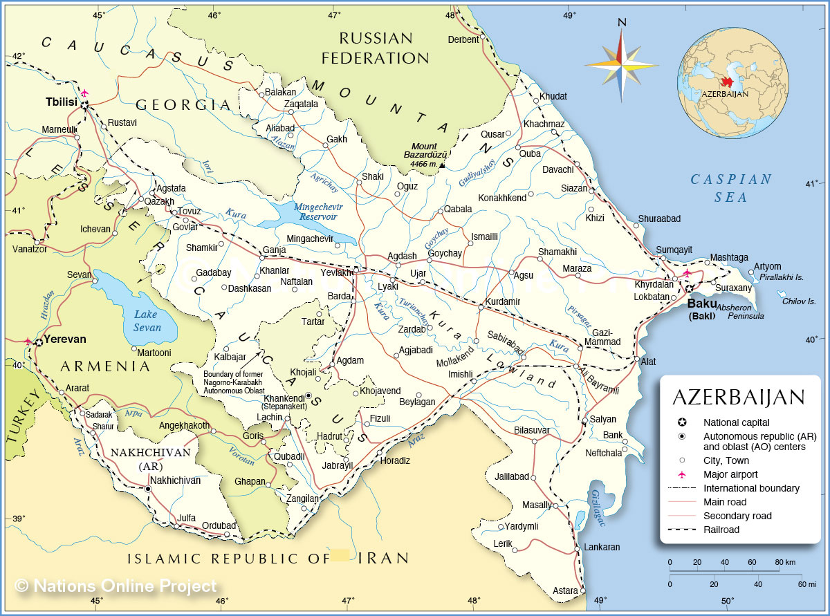
| Map is showing Azerbaijan, a republic in southeastern Europe and Western Asia, in the Caucasus (Transcaucasia), on the western shore of the Caspian Sea. The country is at the crossroads of Eastern Europe and Western Asia, it is bordered by Armenia, Georgia, Iran, Russia, and Turkey. The former Soviet republic gained independence in 1991, its official name is now the Republic of Azerbaijan. The country occupies an area of 86,600 km² (33,440 sq mi), including the exclave of the Naxcivan Autonomous Republic and the disputed Nagorno-Karabakh region, compared the country is slightly larger than Austria or slightly smaller than the U.S. state of Maine. Capital city is Baku. Other major cities are Ganja, Sumqayit, and Mingachevir. Spoken languages are Azerbaijani (Russian and English as second or third languages). Main religion is Islam, about 90% of the population are Muslims. Azerbaijan's climate zones range from arid subtropical to the mountainous tundra. The country is part of an ecoregion encompassing Georgia and Armenia. With 4,466 m (14,652 ft) Mount Bazardüzü (or Bazarduzu Dagi, Kiche suv) in the Greater Caucasus range on the border between Russia and Azerbaijan, is the highest peak in Azerbaijan. The country's main rivers are Kura (Kur) with a length of 1,515 km, it empties into the Caspian Sea, and Aras River, a main tributary of the Kura, with a length of 1,072 km. Depicted on the map are cities, towns, and villages (see below), main roads, railroads and major airports. |  Bookmark/share this page |  One World - Nations Online countries of the world |
 Political Map of Republic of Azerbaijan | |||
| Cities and Towns in Azerbaijan Depicted on the map are the location of following cities and towns: Largest cities: Baku ((Baki) pop. 2 million, capital), Ganja ((Ganca) pop. 313,000), Sumqayit ((Sumgait) pop. 310,000), Mingachevir (pop. 96,000), Khirdalan (pop. 92,000) Other cities and towns in Azerbaijan: Agdam, Agdash, Agjabadi, Agstafa (Aghstafa), Agsu, Alat, Ali Bayramli, Aliabad, Artyom, Astara, Baku (Baki), Balakan, Bank, Barda, Beylagan, Bilasuvar, Dashkasan, Davachi, Fizuli, Gadabay, Gakh, Ganja, Gazi-Lokbatan, Govlar, Goychay, Horadiz, IsmailliImishli, Jabrayil, Jalilabad, Julfa, Kalbajar, Khachmaz, Khanlar, Khizi, Khojavend, Khudat, Khyrdalan, Konakhkend, Kurdamir, Lachin, Lankaran, Lerik, Lyaki, Mammad, Maraza, Masally, Mashtaga, Mingachevir, Mollakend, Naftalan, Nakhichivan, Neftchala, Oguz, Ordubad, Qabala (Gabala), Qazakh (Gazakh), Quba, Qubadli, Qusar, Sabirabad, Sadarak, Salyan, Shaki, Shamakhi, Shamkir, Sharur, Shuraabad, Siazan, Sumqayit, Suraxany, Tovuz, Ujar, Yardymli, Yevlakh, Zangilan, Zaqatala, and Zardab. Cities and towns in Nagorno-Karabakh (Azerbaijan): Khankendi (Stepanakert), Hadrut, Khojali, Tartar. | |||
Comments
Post a Comment